Monday, August 28, 2017

August 8-9 - old school days off - Route 66, Grand Canyon Caverns, and a train ride

Taking some time and exploring in the vicinity of the Grand Canyon, Susan and I discovered more along the Mother Road - Route 66. This highway was the first transcontinental road, winding from Chicago to Santa Monica, California.  Route 66 helped lead people out of the Dust Bowl and to new lives in the golden state of the west - California. 


Parks Grocery has been here since 1905 or so, greeting people headed west before there was even a Route 66.  


 This is some of the original highway, before I-40 bypassed the area.


Imagine families following their dreams as they pushed their way west.  Not much of the original Route 66 remains.  This was the last section bypassed by the interstates.  Route 66 was officially decommissioned in 1985.


Along Route 66, we found Keyhole Sink and more petroglyphs.  Native Americans used petroglyphs and pictographs to tell stories. There must have been a bear in this area; see the bear claw in the lower right corner?


Continuing west on Route 66, Susan and I headed to Grand Canyon Caverns.  Where Old 66 leaves I-40 is Seligman, and these caves are about 50 miles west of Seligman.  With all the limestone under us, it is natural that there would be a lot of caves and caverns in the Grand Canyon area.  (This is about 120 road miles from the South Rim.)  And if you've seen any of the CARS movies, you'll recognize Mater at home here at Radiator Springs.


Grand Canyon Caverns was a Civil Defense shelter back in the 1960s, and is still stocked with supplies...just in case.


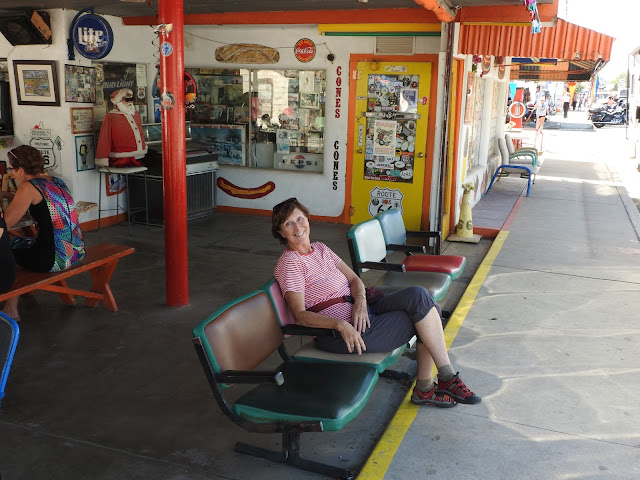
On the way back, we stopped in Seligman at Delgadillo's Snow Cap.  On a hot day, perfect place to enjoy a Butterscotch Milk Shake. Susan didn't want to leave (and neither did I)!


I had trouble figuring out how to get in the door!


As we enjoyed our shake, this was our view across old Route 66.  No traffic...nothin' but time.


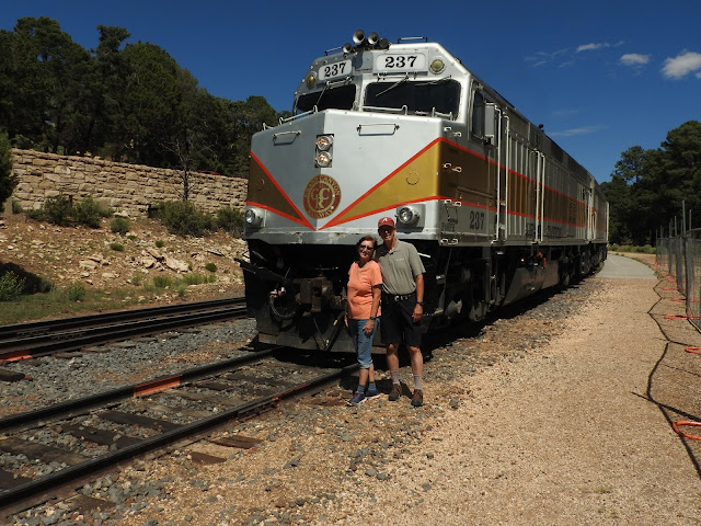
My "bread and butter" tours this year have been meeting the Grand Canyon Railway as it chugs up from Williams, AZ to the Grand Canyon Depot.  So Susan and I thought we'd try it as well!
  

This is our cabin!  Train goes right by here every day.  


Very nostalgic.  The train has been coming here since 1905.


Another fun day off.  Next week, hiking into the Grand Canyon.  Bright Angel Trail down to Indian Garden, then out to Plateau Point.


Saturday, August 12, 2017

August 10 - Rainbows and double rainbows

Wow!!  Were we blessed on Thursday night?!?! My tour was scheduled to be a Sunset Tour along the rim.  But some rain came through, creating some incredible rainbows for us.  This double rainbow was at Bright Angel. It ended right in the middle of Indian Gardens.  I wonder if anyone was digging for the pot of gold down there.


We went out to Pima Point for the actual sunset, but the rainbows just kept coming!


The sunset was good, but the rainbows were the story this night.  

Wednesday, August 9, 2017

August 2 - Petrified Forest National Park and Winslow, Arizona

Last Wednesday, Susan and I enjoyed another of America's incredible national parks - Petrified Forest. It's in northeastern Arizona and straddles I-40 (which parallels Historic Route 66 in many places; more on that later). Affectionately known as Pefo (first 2 letters of the name), Petrified Forest is set in a desert environment. But all the trees - there are many and they were huge - are found only in a tropical location.


After the previous day at Montezuma Castle, we spent the night in Holbrook, AZ, very near the south entrance of Pefo. So we took the in-park road from south to north, which introduced us to the petrified trees first. The north end of the park is near the Painted Desert.


From the Visitor Center, there is an easy 3/10ths mile loop walk that winds through this petrified forest. So how did these tropical trees end up in a desert? Well, about 200 million years ago, this area of northeastern Arizona was actually near the equator; part of the earth's largest landmass, Pangaea.


Rivers were flowing through the area and these giant trees grew up to 10 feet in diameter. As the super-continent broke up and the trees died or were knocked down (by wind or water), most of them decayed (just like you would expect to see in the forest).


However, some logs were buried by sediment of the river before they could decompose. Meanwhile nearby volcanoes spewed ash into the atmosphere.


Ground water dissolved silica from the volcanic ash and carried the solution through the logs. This solution filled the cells and crystallized into the mineral quartz. Iron and other minerals combined with the quartz during the petrification process, creating the rainbow of colors we see today.


Basically the organic cells in the tree are replaced by the quartz minerals, and other minerals provide the colors we see.


Gives some sense of the size of these tree trunks.


This is one tree trunk; check out the people on the right side of the picture.


Today, this area is very hot and very dry, as witness by this lizard sunning himself on a piece of petrified wood.

Sometimes the earth underneath a tree would erode, creating a bridge. This tree has been "shored up" by a bridge of concrete to support it. The Park Service would not do this today. But I'm glad they did (back in the 30's) so we could see how solid and hard these petrified logs are today.


As we drove north and transitioned from the petrified forest to the painted desert area of Pefo, there was an area called Newspaper Rock.  Filled with more petroglyphs (pecked or etched stone), these petroglyphs told about giants (the big figures in the center bottom), dogs, snakes, along with other decorations.


This petroglyph was used to scare children. This bird is carrying off a person (maybe a child?!?!). Must be a very large bird. Check out the person in the upper left corner. Are they trying to startle the bird so it will drop the child?


At the north end of Pefo, we arrived at the Painted Desert Inn. Built in the 1920s and very close to the place where Route 66 cuts across Pefo, it was later run by the Fred Harvey Company (the predecessor to Xanterra, the company Susan and I work for). Perhaps you've heard of the Harvey Girls? It's been said that the Harvey Girls were responsible for the "Taming of the West."


Fred Kabotie, famous Hopi artist who had collaborated with Mary Jane Colter at the Desert View Watchtower in the Grand Canyon, was hired to paint murals at Painted Desert Inn. These are just a few he did.


This is the ceiling of the Painted Desert Inn.  WOW!  These are glass panels in the ceiling.


Route 66 lives today even though the road itself was decommissioned in 1985. This picture was above our bed in Holbrook. Kinda hard to forget how important Route 66 was during the Dust Bowl, World War II, and then to the early baby boom generation. But the interstate highway system became more popular as the need for speed replaced the time on the road for a family vacation. 


This sign describes the place where Route 66 cut across the Pefo main road. The Studebaker jalopy in the background is testament to the millions of people who traversed Route 66 from the midwest to their hoped for dreams of a better life in California.


And of course, no trip to along I-40 and historic Route 66 is complete unless you meet Glenn Fry, standin' on the corner of Winslow, Arizona.


Oh my!  It's a girl...my lord...in a flat bed Ford, slowin' down to take a look at me.


Hope you have a great rest of your week.