Sunday, June 25, 2017

June 20 - Day off with Yellowstone friends

Days off are a precious commodity here, and we were fortunate to have a Yellowstone couple from 2016 join us here in the Grand Canyon.  Karen and Neil Denowitz have been to the Grand Canyon previously but we were able to share some new sights with them.

On the Grand Tour, one of my favorite stops is Mohave Point.  It juts out into the Canyon and has a great view.


From Mohave, we can see Hermit Rapids - a Class 8 rapid on the Colorado River.


And the Alligator too!  Yes...that is the official name of this butte sticking out into the Canyon.


Amazing to see this sheer drop off.


I think that is one of the things that we find so amazing about this place - you can get so close to the edge.  There are so many places along the Rim Trail where there is no railing.  A sheer drop off, several hundred feet down.  Just beyond Mohave Point is an area called the Abyss.  Well named!  

Hope you have a great week.  

June 13 - Day off to Ooh Aah Point

In case you haven’t heard, it’s been sizzling hot here in the Southwest, and Grand Canyon is no exception.  Susan and I have been enduring 90, 92, and 93 degree days for about 10 days now.  I know our friends back in Atlanta have been getting rain (and lots of it!) because our water bill has been running exceptionally low for this time of year.  In a couple of weeks, the Grand Canyon should also be getting rain in the form of monsoons – intense rains with a lot of lightning and thunder.  That should make the tours more interesting for sure, running in and out of my bus! 
 

The thing about the heat is that our tiny cabin isn’t air conditioned.  I did have Home Depot send us a swamp cooler which has helped some.  I can’t imagine what the heat would be like without it.  Working at the Hopi House, Susan has AC only upstairs in the gallery; only fans downstairs.  When Mary Jane Colter built the Hopi House in 1905, the Hopi artisans (weavers, potters, jewelry makers) were actually living upstairs on the 2nd and 3rd floors.   Of course, Colter would never have created a building with AC anyway.  She lived on the Hopi reservation for several months to learn about their pueblo buildings, so she could re-create them here for Grand Canyon visitors.  

And speaking of Hopi, we went out to Hopi Point for sunset one evening.  We can already feel the days are starting to get shorter.  


On our day off, we went hunting for some pictographs that one of the drivers told me about.  They are out the east entrance road.


Never did find them, but got some interesting plant pictures - Indian Paint Brush and prickly pear cactus.  Need to get better instructions and try again!


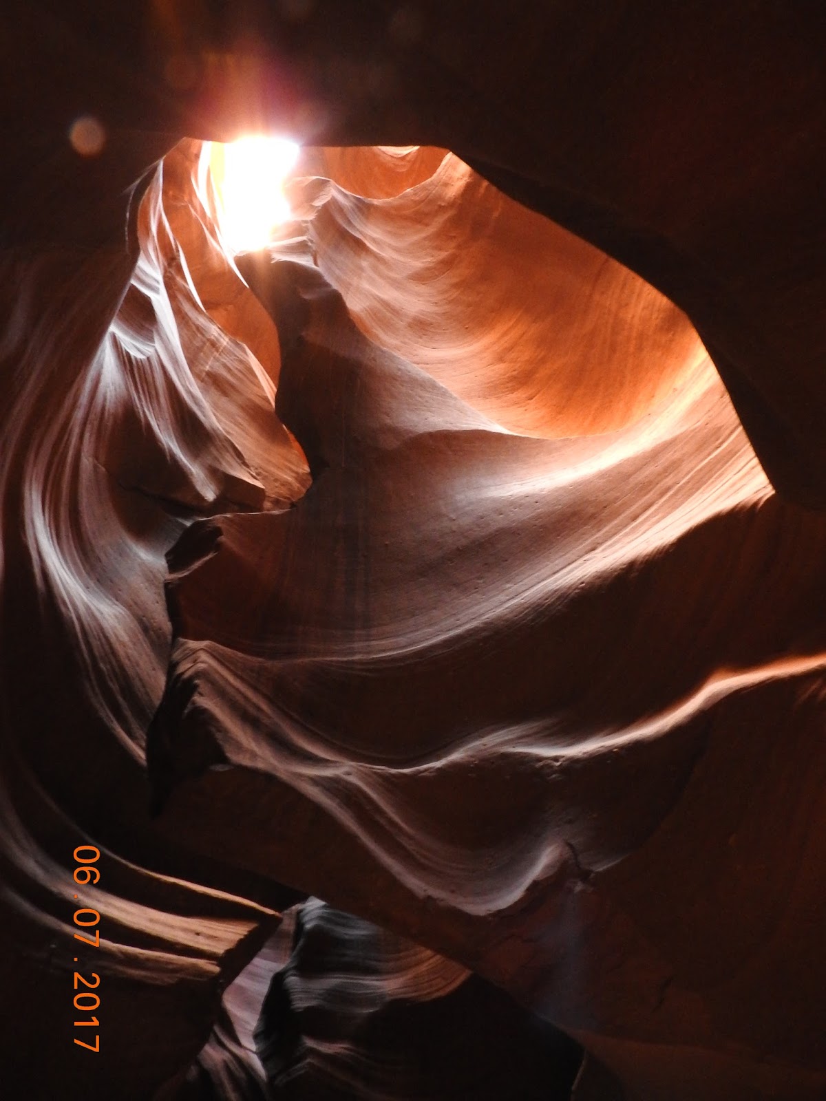
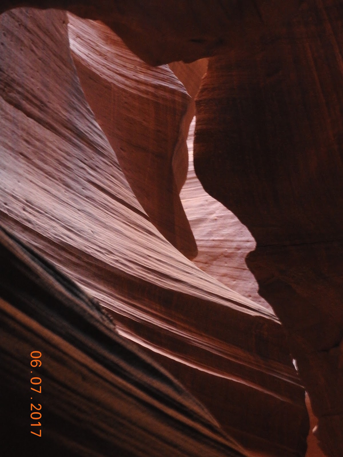
The swirls in these rocks reveal that this area was once under water.  But here we are at 7-thousand feet!  Amazing geology with the Colorado Plateau being uplifted by plate tectonics.  


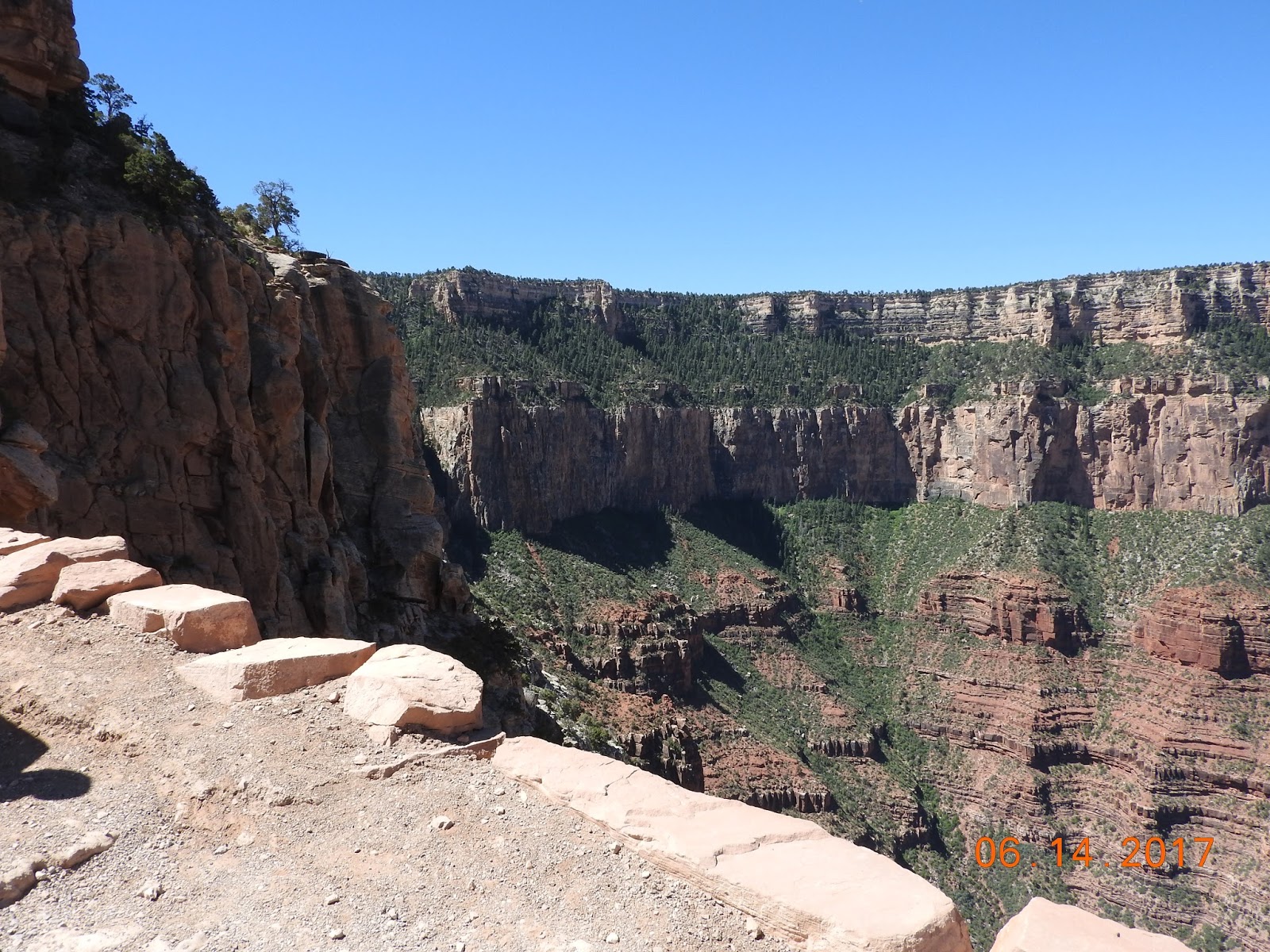
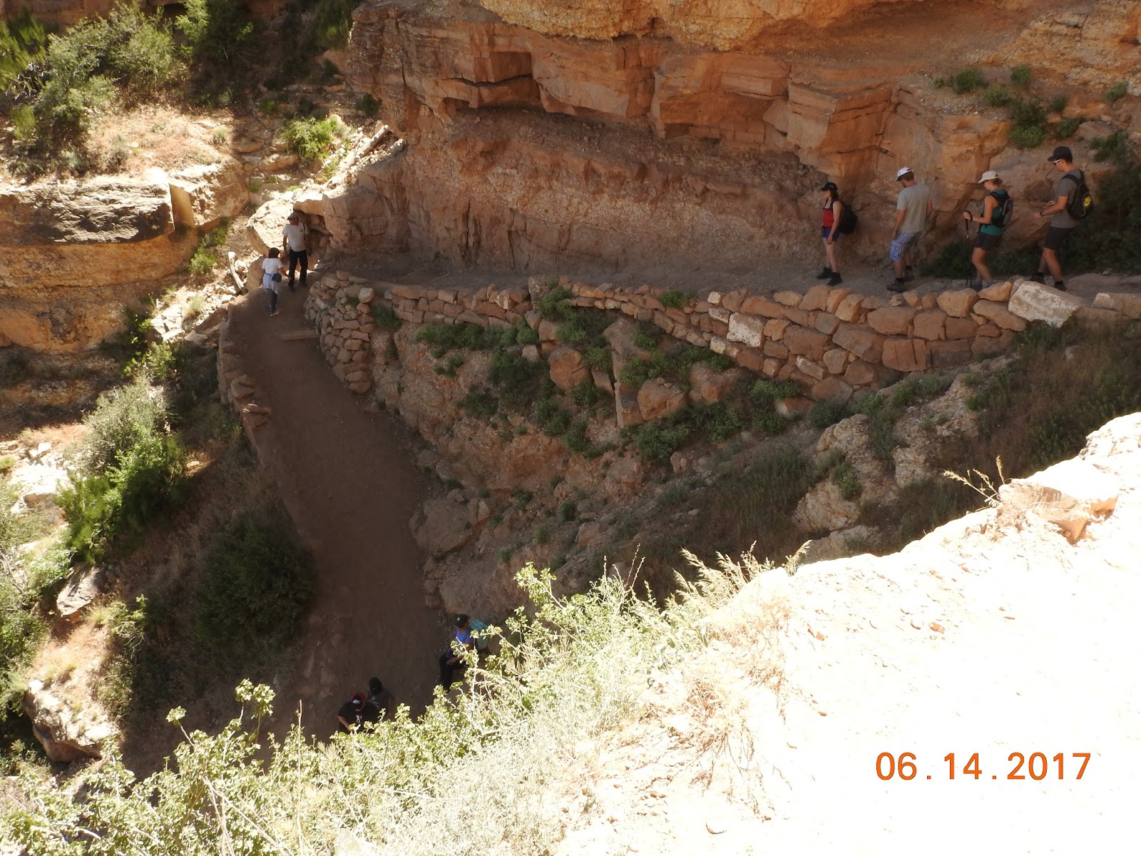
We did a short hike down to a place I've been wanting to go to.  GREAT name - Ooh Aah Point! It's on the South Kaibab Trail and is about 1.5 miles down into the Canyon.  The name says it all.


South Kaibab Trail zig-zags behind us all the way to the Colorado River, another 7 miles from Ooh Ahh Point.  


And from Ooh Aah, we can see the rest station below us - Cedar Ridge.  That is 3 miles down and the water was out.  So we didn't go there.


180 degree panorama at Ooh Aah Point.  


Down is optional; up is mandatory.  As we started up the South Kaibab Trail, the incredible layers of the Grand Canyon were easy to see.


As you can see, South Kaibab is a very steep trail.  


Finding shade along the South Kaibab Trail was at a premium.  


Another sunset from Hopi Point.  


I'm still trying to decide if Hopi Point or Mohave Point has the best sunset location.  Will keep you posted.  ðŸ˜Š  


Friday, June 16, 2017

June 7 (Part 2 of 2) - Antelope Canyon

What an absolutely amazing place this is.  Antelope Canyon.  I've seen pictures from here for at least 20 years.  Arizona Highways has some incredible pictures from here all the time.  And I thought great pictures like those would be out of my reach.  What I learned is that it's next to impossible to take a bad picture in Antelope Canyon.  We had an incredible guide from Antelope Canyon Tours who not only directed traffic (keeping people out of our pictures) but also changed the settings on my camera and Susan's iPhone to get the very best pictures.

On the drive out from Page, the smooth Navajo Sandstone was teasing us with the beauty the lies ahead.


As we started into Antelope Canyon itself, the temperature dropped about 20 degrees and a cool breeze drifted through.  Just a taste of the beauty and sublime nature that was ahead.


Antelope Canyon is a slot canyon, which can be deadly when it rains upstream.  Flash floods can roar down through the slot; even though it is dry where we are standing, rain far upstream (especially during the upcoming monsoon season) can unleash a torrent of water that scours these canyon walls to a smooth finish.


This spot is called "The Heart."


Susan dubbed this one "The Sands of Time."  Our guide carried a small shovel and would flick the sand up onto the shelf, insuring that we capture this shot of the sand in motion.  
Very special.


Our guide had great creativity as well.  


I just love the textures and forms in Antelope Canyon.


This is one of my favorite shots - the contrast of the Navajo Sandstone playing with the light.


As we emerged from the upper end of Antelope Canyon, we knew we had created more spectacular memories.  Besides the Grand Canyon, we hope you'll put Horseshoe Bend and Antelope Canyon on your list of "must see" locations.    


June 7 (Part 1 of 2) - Horseshoe Bend of the Colorado River

Last week, Susan and I did a 2-fer to Page, Arizona.  The first stop was Horseshoe Bend, part of the Glen Canyon National Recreation Area.  The second part was Antelope Canyon on the Navajo Indian Reservation.  I'll post those pics after this.

Horseshoe Bend is a place I've seen in pictures for years...and I'll bet you have too!  It is a 270 degree curve in the Colorado River, 5 miles down river from Glen Canyon Dam.  That dam has certainly changed the Colorado River, taming the fearsome rapids, sending cooler water which impacted fish species, and removing the reddish silt that gave the river its name ... sending the cold, green water we see below downstream instead.


Horseshoe Bend is a 1000 foot overlook.  No railings.  Quite intimidating as you reach the edge and peer over and down into the chasm below. That is one of the big rubber rafts (about 25 feet long) at the bottom of these pictures.


No railings anywhere along this overlook.  Susan was fearless as she approached the edge below.


People peering over the edge.


There were several big rubber rafts getting ready to push off from the shoreline and head down river through the Grand Canyon.  These 2 pictures give some perspective about the size of the rafts and how big and deep Horseshoe Bend is.


 Incredible erosion along the river, scouring out those arcs and (maybe someday) arches.


Long, dry, hot walk out to Horseshoe Bend.  Only 3/4ths mile one way, but sooooo worth it. 

 
When we started the car, this was the outside thermometer reading. 

Back in the Canyon, earlier this week, we had overnight lows in the 30s.  However, summer is back with a vengeance over the weekend. Highs around 90; hot and dry.  Phoenix is predicting 120 degrees this weekend.  Our new swamp cooler will be working overtime for sure!

Next up - Antelope Canyon.