Thursday, September 28, 2017

Sept 20 - Canyonlands National Park

While in Yellowstone and Grand Canyon National Parks the past 2 summers, I often said that each and every national park is unique and special.  Canyonlands National Park in east central Utah certainly nails that definition!!  Susan and I explored only one of the 3 districts in Canyonlands. Called the Needles, it is on the east side of the park and is spectacular.  The other districts are called Island in the Sky and The Maze.  On the west side of the Colorado River, The Maze is one of the most remote areas in the the lower 48 states. No roads; hard to get to; we'll never get there. However, in the northern section, Island in the Sky is an area we will definitely come back to.  Staying in Moab, UT, is the perfect place to enjoy both Canyonlands and Arches National Parks.

To reach the Needles District, we had to drive 35 miles from the main road.  We saw this feature on the way to Canyonlands; I called it "The Capitol." Beautiful, but only a hint at what we'd see inside the park.

Along the way, there was a place called Newspaper Rock. This petroglyph tells many stories. Check out the herd of deer in the upper left; a hunter shooting elk in the upper right; several bear claws and big horn sheep. And some are just designs.


On the way into Canyonlands, we had to stop at the sign and get our first look at this very dry and stark landscape.


We didn't know it when we started hiking, but this is how the Needles District got it's name. Well done!

Our first hike - a short 6/10ths miler around an area called Cave Spring. It contained an old cowboy camp. Easy to understand why cowboys would like it here: nice shady overhang to ward off the intense summer heat; good source of water nearby.


Nice storage box too. 


One of the things we found so unusual is the very distinct line between the red sandstone and white sandstone. Iron oxide mixed with the red sandstone while the white sandstone remained like the sand you find at the beach. It only takes a little color red to make a significant color change.


Susan's on the white sandstone. Amazing to think how clearly defined that line between the red and white sandstone is.


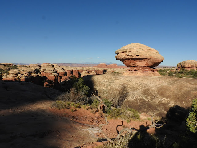
We did see a number of mushrooms and balanced rocks.


Love the tree growing out of the middle of the rock. Tough existence.


Our longer 6 mile hike went up and down 2 ridgelines before reaching Chesler Park.  This is how the Needles District got it's name.

Some rugged hiking; very exposed, meaning hot and dry.  


And narrow too! Several times we had to wait for hikers coming towards us to clear the constricted passageways.


Great beauty, going and coming. Completely different views on the way back.


Couldn't resist a funny picture.


Finally made it back. This is our last downhill. You can see the car in the background. I had not taken enough water; bad planning on my part. But we had the salty snacks we needed and then had a generous lady give us some water that she didn't need (she was headed back and had plenty). So that was VERY helpful.  


This little arch is called Wooden Shoe. Good overlook on the way back to the visitor center and more water.


Yes, Needles District of Canyonlands, we will be back! And I hope you go there too.


Next up...Arches National Park.

Thursday, September 21, 2017

Sept 12 and 13 - Revisit to Wupatki pueblo ruins and some airplanes

These dates were our last days off from our jobs here in the Grand Canyon.  Next week, we're going to visit Canyonlands and Arches National Parks, then to Boulder, CO to see friends there, then home. As Susan and I talked over dinner last night at El Tovar Hotel, we reminisced on our experiences here in the GC and our many, many friends all over the country. Thanks for being part of our lives and enriching us with your friendship.

Wupatki is just east of the Grand Canyon and north of Flagstaff.  The area is full of Indian Pueblos built between 800 and 1,000 years ago. As the Hopi changed from a hunter-gatherer culture to farming, they started building more permanent structures. The keyhole at the front entrance of the front entrance sign is indicative of the doors that they built into their pueblos.


Wupatki is located along Native American trading routes of northern Arizona, so many potsherds, different styles of spear tips, and other evidence of trading are found there. Example: the circular room below was used for commerce and trading.


However, the Hopi did still migrate from place to place, leaving these "permanent" structures behind. Archaeologists aren't sure exactly why they left: perhaps the farming land wore out; perhaps drought; perhaps other tribes stole their crops.  This pueblo is called the Citadel because it sits on top of a tall rise.  


Another great example of location, location, location - this pueblo sits on the edge of a box canyon. Easy to defend. Crops easily cultivated. Easy to store water in the canyon below.


These pics give you some idea of the size of the pueblos...


...and the quality of their construction.  This wall is probably about 800 years old. Amazing!


Just south of the Grand Canyon is a small town called Valle.  There is an airplane museum there called Planes of Fame. They are related to the museum of the same name in Chino, CA.


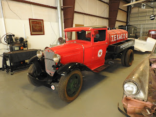
And they have some cool cars and trucks there as well.  Susan was particularly taken with this 2-tone Studebaker. Note the garnet and white steering wheel matches the exterior of the car!


We've had a great summer and so glad to share with you. We're headed home now and will be sharing some incredible pictures from Canyonlands and Arches National Parks in the coming days.

Monday, September 11, 2017

Sept 9 and 11 - Clouds and Sunrise

When most folks think about the Grand Canyon, they envision huge vistas and this immense chasm. And it is that. But the other day, we had rain come through in the morning which left remnants of clouds in the canyon.  This added a whole new dimension to the beauty of this place.   


Below is Cheops Temple with Sumner Peak in the background, engulfed by the clouds.  


This could be one of my favorite pictures. This is the view from Hopi Point across to the North Rim. The top layers of yellow limestone with redwall sandstone underneath, followed by the basement rock of black schist at the bottom. These are the stories I've been telling all summer long.


Then this morning, I had my first sunrise tour in awhile.  It was beautiful to get out on the Rim again and watch the light play across the colors of the Canyon.


The shadows created layer upon layer of vista.  


This feature is called The Alligator.  And the Colorado River is in the background.  


Hard to believe, but this Monday is our last day of work.  We'll be headed back through 2 national parks that have been on our life list for quite sometime - Canyonlands (where the Green River meets the Colorado River) and Arches (look at a Utah license plate). But before then, a couple more blogs should be coming.    

Tuesday, September 5, 2017

August 22-23 - Life list item accomplished - Bright Angel Trail hike out to Plateau Point

I see Plateau Point almost every day and it has had my interest for many years.  On my bus tour, I typically stop at a place called Trailview. There is a great overlook of the Bright Angel Trail and you can see 1 1/2 mile Resthouse, 3 mile Resthouse, on down to Indian Garden (where there is a campground), and then on out to Plateau Point. The hike is 4.5 miles down the Bright Angel Trail to Indian Garden, called that because there are springs which create a wonderful riparian area. Native Americans grew corn, beans, and squash there before being relocated after the national park was formed.

This is the view from Trailview, looking out across the expanse of Plateau Point. That ribbon of trail goes out to a point overlooking the Colorado River. As I say on my tour, "The trail looks like it dead ends out there? It does...800 feet above the Colorado River."


Driving up from Phoenix, my brother Eric joined me at the Bright Angel Trailhead on this hike below the Rim.

This is the Trailview overlook from below. As I say on my tours, there is an overlook with railing. but just to the right of that railing, there is no margin for error.


Bright Angel Trail, stairstepping down the sheer canyon wall.  


Great day to hike, and wonderful views as we descended 3300 feet into the Grand Canyon.  


Early the next morning, it was time to head out 1.5 miles to Plateau Point.  
 

No shade; no cover.  Desert for sure!  About 20 degrees warmer than the Rim.


Prickly pear cactus, just to remind us that we're in the desert.


Then we arrived at the end of the trail.  All this time, looking at Plateau Point...and I never knew there was a fence here. 


And a drinking fountain!


Our company used to offer one day mule rides out to Plateau Point, but no more.  I think that's why the water was there.  

From our perch at Plateau Point overlooking the Colorado River, 800 feet below. 
Rafters had spent the night on the river there.  


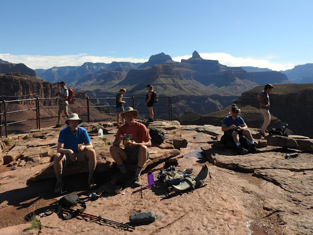
Great spot for breakfast.  


For folks headed down the Bright Angel Trail to the Colorado River and Phantom Ranch, they have to traverse another set of switchbacks (over Eric's shoulder) called the Devil's Corkscrew. It's as difficult as it sounds.


As we started back towards Indian Garden, a last look at the deep Inner Gorge and the muddy river. That is Salt Creek Rapid, a Class 8 on the Colorado.  (Only the Colorado Rivers uses a 1 to 10 rating system for the rapids.)  I zoomed in so you could see how ferocious these rapids are.


Starting the hike back to Indian Garden. Fully exposed to the sun; no shade. 


Back at Indian Garden for the afternoon, it's almost 100 degrees in the shade.

But springs like this gave Indian Garden it's name. 


This lizard had just had lunch. Hilarious action. There was a bug on the trail and the lizard had spotted it. He went about 10 feet in about 1 second, opened his red mouth, and gobbled that insect. Then ran back to this rock. The whole thing happened in less than 4 seconds. 


Back at camp, time to relax...stretch the leg muscles...catch up on some reading (and sleeping).


Not often you see Old Glory snagged on a Century Plant.  But that's what happened at the Indian Garden Ranger Station today. 


Next morning, early start up the 4.5 miles of the Bright Angel Trail.


We had breakfast here at 3 mile Resthouse.  My favorite sign is in the background - Down is Optional; Up is Mandatory.  Always gets a chuckle when I say that on my tour as we're overlooking Plateau Point.


From Indian Garden to 3 Mile Resthouse, there were 13 switchbacks as we gained 1100 feet in elevation.  That is the Bright Angel Fault in the background.


Then from 3 Mile Resthouse to 1 1/2 Mile Resthouse, there were 12 switchbacks as we gained another 1100 feet in elevation.  


And from 1 1/2 Mile Resthouse to the trailhead, there were another 13 switchbacks as we gained another 1100 feet in elevation. 


On this entire 4.5 mile section, there were 2 downhill sections, totaling about 15 feet. And one level spot, about 10 feet long. 
Bottom line - Bright Angel Trail from Indian Garden to the trailhead is all up hill!


Mission accomplished!  Plateau Point in the background.


Thanks Eric for joining me on this memorable hike.